CyArk 3D
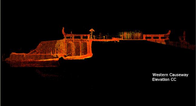
CyArk is a new web resource for distribution of spatial data from archaeological sites - an "open-access digital archive of international archaeological sites" according to the release I got. They've used conventional photography, mapping, and LIDAR (like RADAR with lasers) to put together comprehensive views and information on some World Heritage Sites.
The data is still being collected; most Heritage Sites are not yet available. Also, you'll notice that World Heritage Sites tend to involve monumental architecture and politically complex societies so it's a limited sample from the universe of sites. But lets face it, these are the sites you'd go looking for even if every documented site in the world were available.
Apparently there is also a "Professional Edition" of CyArk, presumably with more detailed information. Access to the Pro version requires a 'review of credentials.' I don't know if any old archaeologist could get that access for shiggles or if you would need some kind of relevant project. A yet higher level of access is called "Site Manager Edition." I'm guessing they aren't looking for those of us who manage completely buried sites without monumental architecture.
I haven't explored enough to find out if there is anything really useful for the everyday archaeologist, but there are some really cool images of a few sites. Plus one of the sites is Deadwood so it automatically gets points from me.
Let me know if you find anything cool.
posted by pughd at
2:41 PM |
![]()